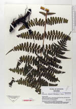
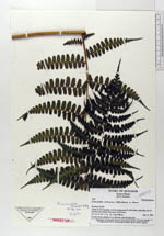
| Collector | Ollgaard, B. |
| Number | 1631 |
| Collected with | H. Navarrete |
| Country | Ecuador |
| Subpart | NAPO |
| County | |
| Locality | Valley of Río Oyacachi, ca 10 km along road W of El Chaco, trail along river to Río San Juan Grande. Remnants of tall forest. |
| Coordinates | 0° 17' S 77° 51' W |
| Minimum elevation (m) | 1760 |
| Maximum elevation (m) | 1800 |
| Start date | 1996/03/12 |
| End date | 1996/03/12 |
| Family | Dennstaedtiaceae |
| Identification | Dennstaedtia auriculata Navarrete & B.Øllg. |
| Determined by | Navarrete, H. & Ollgaard, B. (AAU), 1999 |
| Identification qualifier | |
| Field notes | At trail, leaves scandent, 5 m. Rhizome with elevated apex. |
|