AAU Herbarium Database |
| New Search Modify Search |
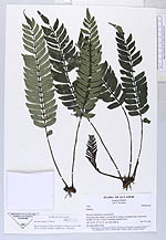
| Collector | Ollgaard, B. |
| Number | 1429 |
| Collected with | H. Navarrete |
| Country | Ecuador |
| Subpart | MORONA-SANTIAGO |
| County | |
| Locality | Trail along Río Inimkis, ca 3 km NE of village of Inimkis (San Luis)toward foothills of Cord. Cutucú. Disturbed montane forest. |
| Coordinates | 2° 23' S 78° 6' W |
| Minimum elevation (m) | 900 |
| Maximum elevation (m) | 1000 |
| Start date | 1995/11/14 |
| End date | 1995/11/14 |
| Family | Marattiaceae |
| Identification | Danaea humilis Moore |
| Determined by | H. Turmisto & J. Keskiniva |
| Identification qualifier | |
| Field notes | On moist shaded slope. |
| |
 Other records of Danaea humilis Other records of Danaea humilisThe map displays only records from the Aarhus Herbarium Database. The records may not represent the full distribution of Danaea humilis |
| New Search Modify Search |