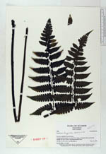
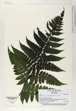
| Collector | Ollgaard, B. |
| Number | 1408 |
| Collected with | H. Navarrete |
| Country | Ecuador |
| Subpart | MORONA-SANTIAGO |
| County | |
| Locality | Trail along Río Inimkis, ca 3 km NE of village of Inimkis (San Luis)toward foothills of Cord. Cutucú. Disturbed montane forest. |
| Coordinates | 2° 23' S 78° 6' W |
| Minimum elevation (m) | 900 |
| Maximum elevation (m) | 1000 |
| Start date | 1995/11/14 |
| End date | 1995/11/14 |
| Family | Dryopteridaceae |
| Identification | Diplazium tungurahuae (Sodiro)C. Chr. |
| Determined by | Navarrete, H. (AAU), 1998. |
| Identification qualifier | |
| Field notes | At river bank, 1.5 m tall. |
|
 Other records of Diplazium tungurahuae