AAU Herbarium Database |
| New Search Modify Search |
| Collector | Ollgaard, B. |
| Number | 106013 |
| Collected with | Navarrete, H. |
| Country | Ecuador |
| Subpart | Loja |
| County | |
| Locality | "Trails ca 5 km ENE of San Pedro de Vilcabamba, Loma and Quebrada El Trigal; light-open low forest on peaty soil, and adjacent sheltered stream ravine." |
| Coordinates | 4° 14' S 79° 10' W |
| Minimum elevation (m) | 2050 |
| Maximum elevation (m) | 2200 |
| Start date | 1994/12/02 |
| End date | 1994/12/02 |
| Family | Dennstaedtiaceae |
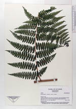
| Identification | Dennstaedtia cicutaria (Sw.)T. Moore |
| Determined by | |
| Identification qualifier | |
| Field notes | Along open trail. |
| |
 Other records of Dennstaedtia cicutaria Other records of Dennstaedtia cicutariaThe map displays only records from the Aarhus Herbarium Database. The records may not represent the full distribution of Dennstaedtia cicutaria |
| New Search Modify Search |