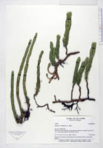
| Collector | Ollgaard, B. |
| Number | 100641 |
| Collected with | |
| Country | Ecuador |
| Subpart | IMBABURA |
| County | |
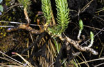
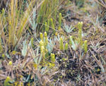
| Locality | Páramo of Volcán Cotacachi, along road from entrance to Laguna Cuicocha, km 10.3. Bunch grass páramo with scrub in ravines. |
| Coordinates | 0° 22' N 78° 19' W |
| Minimum elevation (m) | 3800 |
| Maximum elevation (m) | 3900 |
| Start date | 1993/02/27 |
| End date | 1993/02/27 |
| Family | Lycopodiaceae |
| Identification | Huperzia talpiphila B. Øllg. |
| Determined by | |
| Identification qualifier | |
| Field notes | Rhizome subterranean in black páramo soil, succulent, brittle. In bunch grass páramo. |
|
 Other records of Huperzia talpiphila