AAU Herbarium Database |
| New Search Modify Search |
| Collector | Lojtnant, B. |
| Number | 15611 |
| Collected with | Molau, U. |
| Country | Ecuador |
| Subpart | GUAYAS |
| County | |
| Locality | Hills above Hacienda La Elvira, c. 5 km W of Bucay. Virgin rain forest. |
| Coordinates | 2° 11' S 79° 7' W |
| Minimum elevation (m) | 500 |
| Maximum elevation (m) | 500 |
| Start date | 1979/07/06 |
| End date | 1979/07/06 |
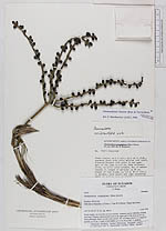
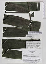
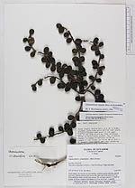
| Family | Arecaceae |
| Identification | Chamaedorea linearis (Ruiz & Pav.)Mart. |
| Determined by | Borchsenius, F. (AAU), 1996. |
| Identification qualifier | |
| Field notes | Stems single, cm 6 m tall, ca 4 cm in diam., unarmed, green with dirty whitish leaf scars. Distance between leaf scars in the upper part of the stem ca 4-5 cm. Stem uniformly thick, no stilt roots present. No. of mature leaves: 5. Length of petiole: ca 30 cm. Length of leaf blade: ca 1.5 m. No of infl.: 3, pendent. |
| |
| Display all 110 georeferenced records of Chamaedorea Chamaedorea linearis |
| New Search Modify Search |