AAU Herbarium Database |
| New Search Modify Search |
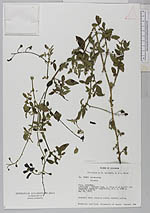
| Collector | Lojtnant, B. |
| Number | 13868 |
| Collected with | Molau, U. |
| Country | Ecuador |
| Subpart | COTOPAXI |
| County | |
| Locality | Latacunga - Quevedo road, c. 10 km W of Pujilí. Dry secondary roadside vegetation. |
| Coordinates | 0° 54' S 78° 42' W |
| Minimum elevation (m) | 3300 |
| Maximum elevation (m) | 3300 |
| Start date | 1979/05/28 |
| End date | 1979/05/28 |
| Family | Solanaceae |
| Identification | Solanum caripense Dunal |
| Determined by | Knapp,S. |
| Identification qualifier | |
| Field notes | Scandent herb. Corolla violet. Anthers yellow. |
| |
| Display all 28 georeferenced records of Solanum Solanum caripense |
| New Search Modify Search |