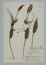
| Collector | Lojtnant, B. |
| Number | 12553 |
| Collected with | Molau, U. & Madison, M. |
| Country | Ecuador |
| Subpart | CARCHI |
| County | |
| Locality | Slopes above the El Carmelo - Tulcán road, c. 10 km NW of El Carmelo. Clearings in cloud forest in ravine. |
| Coordinates | 0° 41' N 77° 40' W |
| Minimum elevation (m) | 3150 |
| Maximum elevation (m) | 3300 |
| Start date | 1979/04/15 |
| End date | 1979/04/15 |
| Family | Orchidaceae |
| Identification | Lepanthes rhombipetala Schltr. |
| Determined by | Luer, C.A. (MO), 1982. |
| Identification qualifier | |
| Field notes | Epiphyte. Sepals purplish red, yellow-greenish tinted on the outer side. Petals and gynostemium bright reddish purple. |
|
 Other records of Lepanthes rhombipetala