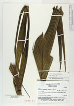
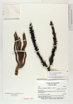
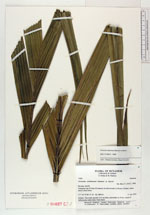
| Collector | Lojtnant, B. |
| Number | 12261 |
| Collected with | Molau, U. & Madison, M. |
| Country | Ecuador |
| Subpart | NAPO |
| County | |
| Locality | Cartagena, km 25 from El Carmelo on road towards La Bonita. Primary, dense, mossy cloud forest. |
| Coordinates | 0° 37' N 77° 30' W |
| Minimum elevation (m) | 2800 |
| Maximum elevation (m) | 2800 |
| Start date | 1979/04/11 |
| End date | 1979/04/11 |
| Family | Arecaceae |
| Identification | Geonoma weberbaueri Dammer ex Burret |
| Determined by | Skov, F. (AAU). 1989. |
| Identification qualifier | |
| Field notes | Solitary. Tree trunk smooth, 8-10 cm thick, internodes ca 10 cm. Leaves 8. Inflorescence infra-foliar. Fruits black. |
|
 Other records of Geonoma weberbaueri