AAU Herbarium Database |
| New Search Modify Search |
| Collector | Lojtnant, B. |
| Number | 11992 |
| Collected with | Molau, U. & Madison, M. |
| Country | Ecuador |
| Subpart | NAPO |
| County | |
| Locality | Cartagena, km 25 from El Carmelo on road towards La Bonita. Primary, dense, mossy cloud forest. |
| Coordinates | 0° 37' N 77° 30' W |
| Minimum elevation (m) | 2800 |
| Maximum elevation (m) | 2800 |
| Start date | 1979/04/08 |
| End date | 1979/04/08 |
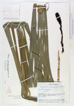
| Family | Cyclanthaceae |
| Identification | Sphaeradenia sanctae-barbarae Harl. |
| Determined by | Eriksson, R. (GB), 1993. |
| Identification qualifier | |
| Field notes | Terrestrial herb in mossy forest, forming thickets. Stem to 6 cm thick, 1 m tall. Leaf bifid, divided three fourth of the length, to 2 m long with petiole. Spike white in flower, becoming green. |
| |
 Other records of Sphaeradenia sanctae-barbarae Other records of Sphaeradenia sanctae-barbaraeThe map displays only records from the Aarhus Herbarium Database. The records may not represent the full distribution of Sphaeradenia sanctae-barbarae |
| New Search Modify Search |