| Collector | Lojtnant, B. |
| Number | 11973 |
| Collected with | Molau, U. & Madison, M. |
| Country | Ecuador |
| Subpart | NAPO |
| County | |
| Locality | Cartagena, km 25 from El Carmelo on road towards La Bonita. Primary, dense, mossy cloud forest. |
| Coordinates | 0° 37' N 77° 30' W |
| Minimum elevation (m) | 2800 |
| Maximum elevation (m) | 2800 |
| Start date | 1979/04/08 |
| End date | 1979/04/08 |
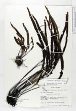
| Family | Pteridaceae |
| Identification | Jamesonia verticalis Kunze |
| Determined by | Arbelaez, A. L. (MO), 2000. |
| Identification qualifier | |
| Field notes | Pendent on roadside banks. Rachis dark brown. |
|
 Other records of Jamesonia verticalis