AAU Herbarium Database |
| New Search Modify Search |
| Collector | Hammel, B. |
| Number | 21358 |
| Collected with | Sylva Koemar |
| Country | Suriname |
| Subpart | Sipaliwini |
| County | |
| Locality | Vicinity of Ulemari River, 13 km upstream from its confluence with Litani River. Primary forest |
| Coordinates | 3° 13' 17'' N 54° 15' 31'' W |
| Minimum elevation (m) | 150 |
| Maximum elevation (m) | 150 |
| Start date | 1998/04/05 |
| End date | 1998/04/05 |
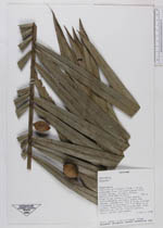
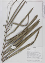
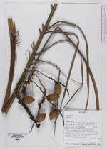
| Family | Arecaceae |
| Identification | Attalea |
| Determined by | |
| Identification qualifier | |
| Field notes | Palm 10 m; without crown shaft. Inflorescence axillary among the leaves. Leaves ca. 2.5 m long, pinnae clustered in groups of 1-4 held in 2 planes, total ca. 70 pinnae per side. Petiole ca. 40. cm. Fruits yellow, juicy, acidic and sweet |
| |
 Other records of Attalea Other records of AttaleaThe map displays only records from the Aarhus Herbarium Database. The records may not represent the full distribution of Attalea |
| New Search Modify Search |