AAU Herbarium Database |
| New Search Modify Search |
| Collector | Eriksen, B. |
| Number | 59370 |
| Collected with | |
| Country | Ecuador |
| Subpart | IMBABURA |
| County | |
| Locality | Laguna Grande de Mojanda, 15 km S of Otavalo. Polylepis forest and disturbed paramo around Laguna Grande and Laguna Negra. |
| Coordinates | 0° 8' N 78° 16' W |
| Minimum elevation (m) | 3750 |
| Maximum elevation (m) | 3750 |
| Start date | 1985/05/14 |
| End date | 1985/05/14 |
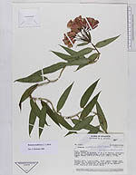
| Family | Alstroemeriaceae |
| Identification | Bomarea multiflora (L. f.)Mirbel |
| Determined by | Hofreiter |
| Identification qualifier | |
| Field notes | Voluble herb, 1.5-2 m long. Outer tepals orange, most intensively so abaxially, the tip purple. Inner tepals orange, most intensively so apically on the abaxial side, adaxially with purple spots. |
| |
| Display all 89 georeferenced records of Bomarea Bomarea Multiflora |
| New Search Modify Search |