AAU Herbarium Database |
| New Search Modify Search |
| Collector | Boyle, B. |
| Number | 2216 |
| Collected with | |
| Country | Ecuador |
| Subpart | Carchi |
| County | |
| Locality | Cerro Golondrinas. Upper Río Gualpi headwaters, north-facing slope beyond (to north of) ridge crest at 2300 m which rises abive the settlements of El Carmen and La Primavera. Primary forest. Upper montane pluvial forest |
| Coordinates | 0° 50' N 78° 13' W |
| Minimum elevation (m) | 2250 |
| Maximum elevation (m) | 2265 |
| Start date | 1993/07/15 |
| End date | 1993/07/20 |
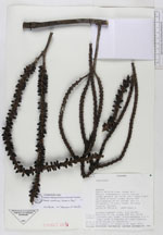
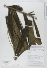
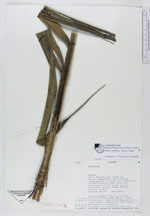
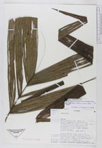
| Family | Arecaceae |
| Identification | Geonoma weberbaueri Dammer ex Burret |
| Determined by | F.Borchsenius |
| Identification qualifier | |
| Field notes | Single stemmed tree, 6.5 cm dbh. Petiole 37 cm, blade 139 cm. 19-22 leaflets per side. Inflorescence 1.4 m long, with 3 degrees of ramification, 9 multiple branches and several singles off main axis. TRansect 2250-2. |
| |
 Other records of Geonoma weberbaueri Other records of Geonoma weberbaueriThe map displays only records from the Aarhus Herbarium Database. The records may not represent the full distribution of Geonoma weberbaueri |
| New Search Modify Search |