AAU Herbarium Database |
| New Search Modify Search |
| Collector | Bergmann, B. |
| Number | 97824 |
| Collected with | Pedersen, H. B. |
| Country | Ecuador |
| Subpart | NAPO |
| County | |
| Locality | Rio Tibutini, 2 1/2 h upstream from Via Auca, left side of the river. Primary forest. |
| Coordinates | 0° 44' S 76° 56' W |
| Minimum elevation (m) | 370 |
| Maximum elevation (m) | 370 |
| Start date | 1991/07/21 |
| End date | 1991/07/23 |
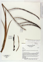
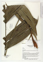
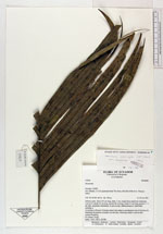
| Family | Arecaceae |
| Identification | Geonoma interrupta var. euspatha (Burret)A.J.Hend. |
| Determined by | F. Borchsenius |
| Identification qualifier | |
| Field notes | Solitary palm. Stem 225 cm long, diam. 2 cm, rough from numerous leafscares. Leaves14; sheath 12 cm long; petiole 46 cm long; rachis 51 cm long; pinnae 2 - 3 per side, irregularly distributed, of uneven size. Inflorescences 2, interfoliar; rachillae 9. According to Ernesto Tseremp (shuar) this palm is considered as one of the best for thatching; the petiole is heated over the fire, following which it can be bent without breaking. Nv (shuar) Turuji. Dubl.: AAU, QCA, QCNE. |
| |
 Other records of Geonoma interrupta var. euspatha Other records of Geonoma interrupta var. euspathaThe map displays only records from the Aarhus Herbarium Database. The records may not represent the full distribution of Geonoma interrupta var. euspatha |
| New Search Modify Search |