AAU Herbarium Database |
| New Search Modify Search |
| Collector | Bergmann, B. |
| Number | 97817 |
| Collected with | Knudsen, J. T. & Tollsten, L. |
| Country | Ecuador |
| Subpart | NAPO |
| County | |
| Locality | INIAP station "San Carlos" km 35 on the Coca - Lago Agrio road. Primary forest, tierra fierma. |
| Coordinates | 0° 18' S 76° 52' W |
| Minimum elevation (m) | 300 |
| Maximum elevation (m) | 300 |
| Start date | 1991/05/21 |
| End date | 1991/05/21 |
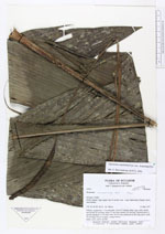
| Family | Arecaceae |
| Identification | Geonoma macrostachys var. macrostachys Mart. |
| Determined by | F. Borchsenius |
| Identification qualifier | |
| Field notes | Solitary, acaulecent, 1.5 m tall palm. Leaves 9; lamina entire, apex bifid; sheath and petiole 35 cm long; rachis 73 cm long; lamina 105 cm long. Inflorescences 2, spicate; prophyll 15 cm long; bract 36 cm long; peduncle 63 cm long, green; spike 18 cm long, 0.8 cm in diam., orange-brown. Dubl.: AAU, QCA, QCNE. |
| |
| Display all 220 georeferenced records of Geonoma Geonoma macrostachys var. macrostachys |
| New Search Modify Search |