| Collector | Bergmann, B. |
| Number | 62565 |
| Collected with | Pedersen, H. B. |
| Country | Ecuador |
| Subpart | PASTAZA |
| County | |
| Locality | Puyo-Baños road, 6 km above Mera. Primary forest on steep slopes on the N side of Rio Pastaza. Along trail from the road to a small bridge. |
| Coordinates | 1° 28' S 78° 10' W |
| Minimum elevation (m) | 1080 |
| Maximum elevation (m) | 1080 |
| Start date | 1988/05/16 |
| End date | 1988/05/16 |
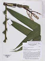
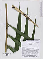
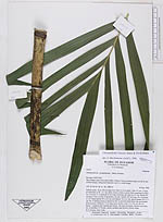
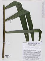
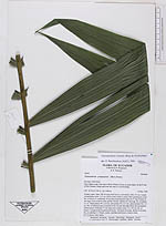
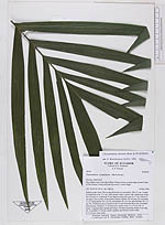
| Family | Arecaceae |
| Identification | Chamaedorea linearis (Ruiz & Pav.)Mart. |
| Determined by | Borchsenius, F. (AAU), 1996. |
| Identification qualifier | |
| Field notes | Solitary palm. Stem 238 cm long from base to crownshaft. Dbh. 4.5 cm. Length of internodes at bh. 11.5 cm. Stem creamy-white to green with conspicuous nodes. No. of leaves 4. Leafsheath 76 cm long encircling the stem for 37 cm. Petiole 62 cm long. Cross section of the petiole circular. Rachis 165 cm long. No. of pinnae 2 x 27. Basal pinnae 40 x 2.6 cm, mid pinnae 50 x 6.2 cm, apical pinnae 24 x 3.3 cm. No. of inflorescences 2 inserted at the 1st and 2nd node below the crownshaft. Inflorescence: Peduncle 17 cm long cross section ovate 1.2 x 0.9 cm. No. of bracts: 1 prophyll and 4 peduncular bracts. All bracts decaying. Rachis 6 cm long. No. of rachillae 13. Petiole, rachis, rachillae and flowers creamy-white. N.V.:Corosa, Uses: none. |
|