AAU Herbarium Database |
| New Search Modify Search |
| Collector | Bergmann, B. |
| Number | 62169 |
| Collected with | Pedersen, H. B. |
| Country | Ecuador |
| Subpart | NAPO |
| County | |
| Locality | Archidona - Tena road km 4. Primary forest on slopes. |
| Coordinates | 0° 56' S 77° 50' W |
| Minimum elevation (m) | 800 |
| Maximum elevation (m) | 800 |
| Start date | 1987/05/03 |
| End date | 1987/05/03 |
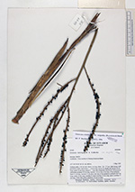
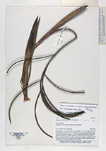
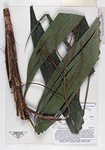
| Family | Arecaceae |
| Identification | Geonoma euspatha Burret |
| Determined by | A. Henderson |
| Identification qualifier | |
| Field notes | Solitary palm, 2.25 cm tall. Stem 1 m long, diam. 1.8 - 2.3 cm, light brown with prominent nodes; internodes 1 - 1.8 cm long; leaves 12; sheath and petiole 98 cm long; rachis 52 cm long; pinnae 2 - 3 per side, irregularly distributed. Inflorescence infrafoliar; prophyll 25 cm long, inserted 1.8 cm above the base of the peduncle; bract 21 cm long, inserted 17 cm above the base of the peduncle; peduncle 40.5 cm long; rachis 12 cm long, rachillae 8, basal rachillae 24 cm long, apical rachillae 17 cm long. Fruits dark green, glabrous, 0.4 cm in diam. |
| |
 Other records of Geonoma euspatha Other records of Geonoma euspathaThe map displays only records from the Aarhus Herbarium Database. The records may not represent the full distribution of Geonoma euspatha |
| New Search Modify Search |