AAU Herbarium Database |
| New Search Modify Search |
| Collector | Bergmann, B. |
| Number | 62166 |
| Collected with | Pedersen, H. B. |
| Country | Ecuador |
| Subpart | NAPO |
| County | |
| Locality | Payamino, INIAP. Primary forest on slopes. |
| Coordinates | 0° 27' S 77° 0' W |
| Minimum elevation (m) | 250 |
| Maximum elevation (m) | 250 |
| Start date | 1987/04/23 |
| End date | 1987/04/23 |
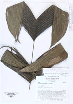
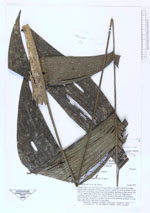
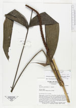
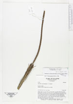
| Family | Arecaceae |
| Identification | Geonoma stricta var. trailii (Burret)A.J.Hend. |
| Determined by | Borchsenius, F. (AAU), 1996. |
| Identification qualifier | |
| Field notes | Solitary palm, 3.5 m tall. Stem 2 m long, diam 1 cm, green with brown nodes, bamboo-like; internodes 5.5 cm long. Leaves 9; sheath 34 cm long; petiole 42 cm long; rachis 42 cm long; pinnae 3 per side, regularly distributed, basal pinnae 35 X 7.7 cm, middle pinnae 40 X 10 cm, apical pinnae 32 X 8.5 cm. Inflorescence interfoliar, spicate; prophyll 12.5 cm long, inserted at the base of the peduncle; bract 4 cm long, inserted 2.7 cm above the base of the peduncle; peduncle 12.5 cm long; spike 24 cm long, diam. 0.8 cm, green. |
| |
| Display all 69 georeferenced records of Geonoma Geonoma stricta var. trailii |
| New Search Modify Search |