AAU Herbarium Database |
| New Search Modify Search |
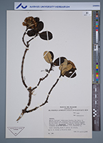
| Collector | Larsen, B.B. |
| Number | 140 |
| Collected with | Birgitte Dall |
| Country | Ecuador |
| Subpart | Loja |
| County | |
| Locality | Parque Nacional Podocarpus. Sendero San Pedro de Vilcabamba-Laguna Banderrilla, 9 km al este de san Pedro de Vilcabamba. Bosque montano húmedo dominado por Weinmannia y áreas de vegetación secondaria cerca del sendero |
| Coordinates | |
| Minimum elevation (m) | 3100 |
| Maximum elevation (m) | 3250 |
| Start date | 1985/08/14 |
| End date | 1985/08/14 |
| Family | Asteraceae |
| Identification | Gynoxys |
| Determined by | |
| Identification qualifier | |
| Field notes | Arbol delgado, hssta 4 metros de altura |
| |
| This record has no coordinates. Display map with the 41 georeferenced records of Gynoxys in the AAU Herbarium Database. |
| New Search Modify Search |