| Collector | Klitgaard, B. B. |
| Number | 344 |
| Collected with | P. Lozano, N. Aguirre & I. Aldaz |
| Country | Ecuador |
| Subpart | ZAMORA-CHINCHIPE |
| County | |
| Locality | Footpath to Rio San Francisco (towards Parque Nacional Podocarpus) off new road Loja-Zamora, km 23-24 |
| Coordinates | 3° 58' S 79° 5' W |
| Minimum elevation (m) | 2100 |
| Maximum elevation (m) | 2100 |
| Start date | 1996/09/26 |
| End date | 1996/09/26 |
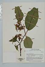
| Family | Solanaceae |
| Identification | Solanum poeppigianum Sendt. |
| Determined by | Knapp, S. (BM), 1999. |
| Identification qualifier | |
| Field notes | "Humid montane forest. Shrub to 3.5 m. Branchlets dark brwn densely tomentose, spiny. Leaves with blade tomentose, midvein more so. Calyx, pedicel tomentose as branchlets; corolla white on outer surface; stamens yellow basally, brown apically." |
|
 Other records of Solanum poeppigianum