AAU Herbarium Database |
| New Search Modify Search |
| Collector | Barfod, A.S. |
| Number | 60184 |
| Collected with | Birgitte Bergmann & Henrik Borgtoft Pedersen |
| Country | Colombia |
| Subpart | NARINO |
| County | |
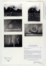
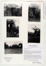
| Locality | Depto Nariño, Tumaco-Cali rd. km 15, pasture land with small forest remnants. Individuals of Phytelephas tumacana not sown but left from cutting of the forest. Reproduction seemingly extremely succesfull in forest remnants. A dense under cover of juvenile plants seen here. In grassed parts no seedlings seen although many seeds are observed on the ground. |
| Coordinates | 1° 59' N 78° 45' W |
| Minimum elevation (m) | 20 |
| Maximum elevation (m) | 50 |
| Start date | 1987/02/05 |
| End date | 1987/02/05 |
| Family | Arecaceae |
| Identification | Phytelephas tumacana Cook |
| Determined by | Barfod, A.S. (AAU), 1988. |
| Identification qualifier | |
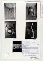
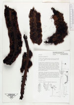
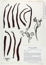
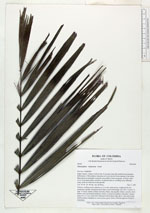
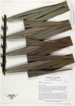
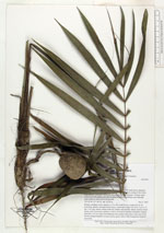
| Field notes | Solitary, medium-sized, palmtree to 5 m tall; trunk brown, roughened by the projecting, spirally arranged petiole bases, internodal lenght very short. Leaves 11, app. 5 m long, lamina outline narrowly elliptic and apically obtuse; petioles short; pinnae with a prominent midnerve, below covered by lepidote tomentum; longest pinna 65 x 4.5 cm; rachis first flattened with median ridge above, then narrowing and becoming triangular in cross section, green, below with ferrugenous lepidote tomentum. |

| |
 Other records of Phytelephas tumacana Other records of Phytelephas tumacanaThe map displays only records from the Aarhus Herbarium Database. The records may not represent the full distribution of Phytelephas tumacana |
| New Search Modify Search |