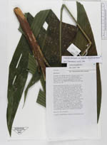
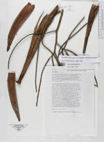
| Field notes | Solitary understory palm, 290 cm tall with upright somewhat twisting stem; adventitious roots numerous at basal nodes; stem 1 m long from base to lowermost leaf, light brown, number of nodes 54, internodal length to 3 cm., diam. of stem at 40 cm from base 2.5 cm. Leaves 7, old leaf remnants present; sheath app. 15 cm long, basalmost 3 to 4 cm encircling, the remaining part marginally with fibrous, brown mesh; petiole 69 cm long, convex-concave in cross section and 0.4 cm in diam.; rachis 74 cm long; number of pinnae 2 X 5 (+1), of uneven size, falcate, opposite to alternate, regularly to irregularly distributed, central pinnae largest 50 X 8 cm. Inflorescence: Peduncle 41 cm long, green, oval in cross section, widest diam. 1.1 cm; prophyll 29 cm, bicarinate, brown, chartaceous, with ferrugenous feltation, splitting laterally in both sides; sheathing bract much like prophyll, same length and characteristics; rachis 21 cm long; number of rachillae 20, the proximal ones born on sidebranches; rachillae 19 cm long and 0.3 cm in diam. Duplicates: QCA (2), MECN (1) |
 Other records of Geonoma interrupta var. euspatha