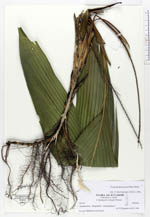
| Field notes | Understory palm, 180 cm tall, basally with 18 smooth adventitious roots without lenticels, 0.6 cm in diam.; stem 30 cm long from uppermost adventitious roots to lowermost leaf, yellowish green; leafscars 13, internodal length 2.2 cm basally to 7 cm apically. Number of leaves five, one juvenile spear shaped leaf; sheath 20 cm long, light green, the lowermost 5 cm encircling; petiole 15 cm long and 0.7 in diam.; rachis 48 cm long; lamina bifid, 60-80 cm long, 25-30 cm broad. Inflorescences: 7, interfoliar, spicate, inserted in groups of three; peduncle 15-20 cm long and 0.2-0.3 cm in diam.; rachis from 15 to 45 long and light green. Infructescence (from other nearby growing individual): peduncle 44 cm, rachis 52 cm. Fruits ovoid, 0.5 x 1 cm, green. Dupl. QCA, MECN |