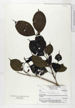
| Collector | Barfod, A.S. |
| Number | 48918 |
| Collected with | Kvist, L. P. & Nissen, D. |
| Country | Ecuador |
| Subpart | CARCHI |
| County | |
| Locality | San Marcos valley. Farmland and rain forest disturbed by the local Coaiquer (Awa) Amerindians. |
| Coordinates | 1° 7' N 78° 22' W |
| Minimum elevation (m) | 600 |
| Maximum elevation (m) | 600 |
| Start date | 1983/11/20 |
| End date | 1983/11/24 |
| Family | Melastomataceae |
| Identification | Topobea caudata Wurdack |
| Determined by | Renner, S.S. (AAU), 1991. |
| Identification qualifier | |
| Field notes | Shrub, 2 m. Add. notes: the fruits are said to be eaten by birds. |
|
 Other records of Topobea caudata