AAU Herbarium Database |
| New Search Modify Search |
| Collector | Henderson, A. |
| Number | 1659 |
| Collected with | E.Ferreira, F.Chavez & J.Guedes |
| Country | Brazil |
| Subpart | |
| County | |
| Locality | Acre, Rio Juruá, above Cruzeiro do Sul, near Natal |
| Coordinates | 8° 20' S 72° 15' W |
| Minimum elevation (m) | 0 |
| Maximum elevation (m) | 0 |
| Start date | 1992/02/08 |
| End date | 1992/02/08 |
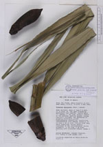
| Family | Arecaceae |
| Identification | Attalea phalerata Mart. |
| Determined by | Borchsenius, F. |
| Identification qualifier | |
| Field notes | Stem solitary, more or less 8 m tall, 35 cm diam, at the apex covered by persistent leaf sheaths. Leaves about 17; sheath 1.7 cm long, without fibres on the margins; petiole absent; pinnae regurlarly arranged, but spreading in slightly differents planes. Inflorescence interfoliar, pistillate inflorescence club shaped, rachilla 50 cm long x 18 cm wide, covered with very short rachillae; fruits densely clustered in the inflorescence; fruits prismatic, 11 cm long, 5 cm diam; endocarp with clustered fibers; seeds 1-3 |
| |
 Other records of Attalea phalerata Other records of Attalea phalerataThe map displays only records from the Aarhus Herbarium Database. The records may not represent the full distribution of Attalea phalerata |
| New Search Modify Search |