AAU Herbarium Database |
| New Search Modify Search |
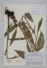
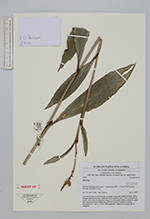
| Collector | Poulsen, A.D. |
| Number | 2542 |
| Collected with | B.Bau, M.Supuma, N.Lettie, J.Khol |
| Country | Papua New Guinea |
| Subpart | Eastern Higland |
| County | |
| Locality | Gahavisuka NP, c. 9 km N of Goroka. Primary montane forest. |
| Coordinates | 6° 1' S 145° 25' E |
| Minimum elevation (m) | 2300 |
| Maximum elevation (m) | 2300 |
| Start date | 2007/01/07 |
| End date | 2007/01/07 |
| Family | Zingiberaceae |
| Identification | Riedelia |
| Determined by | |
| Identification qualifier | |
| Field notes | Terrestial herb to 80 cm tall, in clump. Base and sheath reddish. Bract orange dark red at apex. Inflorescence terminal, erect. Axis, pedicel and ovary red. Calyx translucent orange. Corolla pale yellow, cream in upper half. Immature fruit ellipsoid, greenish brown. Pseudoviviarous. Material in siprit. DNA sampled. |
| |
 Other records of Riedelia Other records of RiedeliaThe map displays only records from the Aarhus Herbarium Database. The records may not represent the full distribution of Riedelia |
| New Search Modify Search |