AAU Herbarium Database |
| New Search Modify Search |
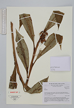
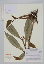
| Collector | Poulsen, A.D. |
| Number | 2515 |
| Collected with | |
| Country | Papua New Guinea |
| Subpart | Morobe |
| County | |
| Locality | Bulolo District. West Watut timber Right Purchase Area. Gumi Ridge. Secondary montane forest dominated by Eleocarpaceae, Fagacea and Cunoniaceae. |
| Coordinates | 7° 11' S 146° 28' E |
| Minimum elevation (m) | 2150 |
| Maximum elevation (m) | 2150 |
| Start date | 2006/12/24 |
| End date | 2006/12/24 |
| Family | Zingiberaceae |
| Identification | Riedelia |
| Determined by | |
| Identification qualifier | |
| Field notes | Terrestial herb to 15 cm. Leaves dark green above, pale beneath. Inflorescence terminal, unbranched. Supporting bracts pale brown. Pedicel and calyx red. Flowers pale yellow. Young fruit reddish brown. Mature fruit ellipsoid, red, opening i 2 halves. Aril pale orange. Material in siprit. DNA sampled. |
| |
 Other records of Riedelia Other records of RiedeliaThe map displays only records from the Aarhus Herbarium Database. The records may not represent the full distribution of Riedelia |
| New Search Modify Search |