AAU Herbarium Database |
| New Search Modify Search |
| Collector | Poulsen, A.D. |
| Number | 2511 |
| Collected with | B.Bau, D.Bosimbi, D.Martin, M.Hinato |
| Country | Papua New Guinea |
| Subpart | Morobe |
| County | |
| Locality | Bulolo District. West Watut timber Right Purchase Area. Gumi Ridge. Secondary montane forest dominated by Eleocarpaceae, Fagacea and Cunoniaceae. |
| Coordinates | 7° 11' S 146° 28' E |
| Minimum elevation (m) | 2150 |
| Maximum elevation (m) | 2150 |
| Start date | 2006/12/23 |
| End date | 2006/12/23 |
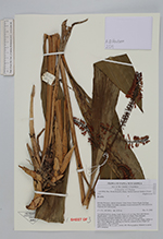
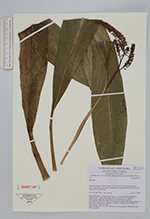
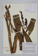
| Family | Zingiberaceae |
| Identification | Riedelia |
| Determined by | |
| Identification qualifier | |
| Field notes | Terrestial herb in clump. Leafy shoot to 1.1 m long. Base pale brown. Sheath green. Lamina mid-green, narrowly, elliptic, base attenuate. Inflorescence terminal, branched with 4-6 side branches, raches chocolate-brown. Ovary dark-red. Calyx pale red. Corolla orange, darker at apex. Fruits subglobose, splitting i 2 halves, reddish brown, bright red when mature. Aril yellowish. Material in siprit. DNA sampled. |
| |
 Other records of Riedelia Other records of RiedeliaThe map displays only records from the Aarhus Herbarium Database. The records may not represent the full distribution of Riedelia |
| New Search Modify Search |