AAU Herbarium Database |
| New Search Modify Search |
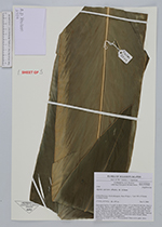
| Collector | Poulsen, A.D. |
| Number | 2504 |
| Collected with | F.Pitisopa, W.Maisa |
| Country | Solomon Islands |
| Subpart | Estern |
| County | |
| Locality | Kolombangara. Rauo Ridge c. 5 km SW of Puitete. Lowland forest. |
| Coordinates | 7° 55' S 157° 6' E |
| Minimum elevation (m) | 450 |
| Maximum elevation (m) | 450 |
| Start date | 2006/12/09 |
| End date | 2006/12/09 |
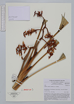
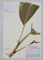
| Family | Zingiberaceae |
| Identification | Alpinia pulchra K.Schum. |
| Determined by | |
| Identification qualifier | |
| Field notes | Terrestial herb to 5 m tall, in dense clump (< 5 cm between shoots). Base to 7 cm diam., brown, with supportive roots. Ligule to 12 mm long, greenish brown. Petiole to 11 cm. Lamina to 125 x 21 cm, pubescent beneath, dark green. Inflorescence terminal, with 3-4 branches. Calyx pale pink. Flower white except for dorsal lobe apex tinged pink ans stigma pale pink. Fruit red turning black when ripe. Seeds black. Vernacular name: bunati (Birau language; informant from Guadalcanal). |
| |
 Other records of Alpinia pulchra Other records of Alpinia pulchraThe map displays only records from the Aarhus Herbarium Database. The records may not represent the full distribution of Alpinia pulchra |
| New Search Modify Search |