AAU Herbarium Database |
| New Search Modify Search |
| Collector | Poulsen, A.D. |
| Number | 2479 |
| Collected with | Kevin Johns Ruhumane & Ataban Uia |
| Country | Solomon Is |
| Subpart | Makira Island |
| County | |
| Locality | Trail between Warito and Bonpusu Planted at stream near deserted forest garden. |
| Coordinates | 10° 30' S 161° 54' E |
| Minimum elevation (m) | 515 |
| Maximum elevation (m) | 0 |
| Start date | 2006/11/26 |
| End date | 0/00/00 |
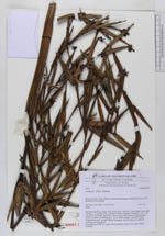
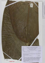
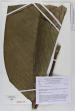
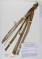
| Family | Marantaceae |
| Identification | Phrynium rubrum (Valeton) Suksathan & Borchs. |
| Determined by | F.Borchsenius |
| Identification qualifier | |
| Field notes | Terrestrial herb in clump. One leafy shoot consists of one leafless bract and 5 leaves. 2.3 m from base of shoot to base of lamina. Lamina to 110 x 38 cm, brown beneath, especially when young. Inflorescence appearing in centre of shoot, branching at c. 1.5 m. Bracts purple. Flowers cream. Vernacular name: ra mera (Bauro language, mera means red; used for cooking and wrapping). Photographed. Material in spirit. DNA sampled. |
| |
 Other records of Phrynium rubrum Other records of Phrynium rubrumThe map displays only records from the Aarhus Herbarium Database. The records may not represent the full distribution of Phrynium rubrum |
| New Search Modify Search |