AAU Herbarium Database |
| New Search Modify Search |
| Collector | Poulsen, A.D. |
| Number | 2477 |
| Collected with | K.J.Ruhumane, A.Uia |
| Country | Solomon Islands |
| Subpart | Makira Island |
| County | |
| Locality | Trail between Warito and Bonpusu. Secondary forest near trail. |
| Coordinates | 10° 29' S 161° 54' E |
| Minimum elevation (m) | 240 |
| Maximum elevation (m) | 240 |
| Start date | 2006/11/26 |
| End date | 2006/11/26 |
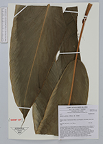
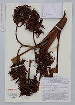
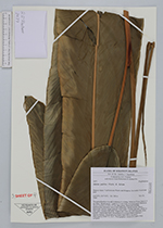
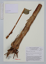
| Family | Zingiberaceae |
| Identification | Alpinia pulchra K.Schum. |
| Determined by | |
| Identification qualifier | |
| Field notes | Terrestial herb to 4 m tall, 6 shoots in a clump. Stilted to 10 cm. Base to 7 cm diam. Sheath green. Ligule to 15 mm long, brownish green. Petiole to 16 cm. Lamina to 120 x 23 cm, dark green, pubescent beneath. Inflorescence terminal, erect with 4 branches. Rachis brown. Bracts telescopic, brown, upper pinkish. Calyx pink. Corolla pale pink, darker at lobe apex. stamen aple pink. Stigma red. Fruit red, dark burgundy when mature. Vernacular name: baramaraovovo (coastal Bauro language=Ngaoni dialect). Observed at not higher than 500 m elevation. |
| |
 Other records of Alpinia pulchra Other records of Alpinia pulchraThe map displays only records from the Aarhus Herbarium Database. The records may not represent the full distribution of Alpinia pulchra |
| New Search Modify Search |