AAU Herbarium Database |
| New Search Modify Search |
| Collector | Poulsen, A.D. |
| Number | 2472 |
| Collected with | B.Bau, J.Noga, E.Suaroh |
| Country | Solomons Islands |
| Subpart | |
| County | |
| Locality | Makira Island. 2.75 km W of Kirakira, 750 m from nearest village (Tawaitara). Forest with som selective logging. |
| Coordinates | 10° 28' S 161° 57' E |
| Minimum elevation (m) | 65 |
| Maximum elevation (m) | 65 |
| Start date | 2006/11/23 |
| End date | 2006/11/23 |
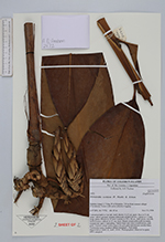
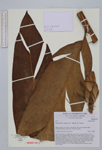
| Family | Zingiberaceae |
| Identification | Hornstedtia scottiana (F.Muell.) K.Schum. |
| Determined by | |
| Identification qualifier | |
| Field notes | Terrestial herb to 5 m tall.Leafy shoots 10-13 cm apart. Base to 5 cm diam., above ground, creamy pubescent ad dark brown. Ligule to 13 mm long, green. Petiole to 15 mm. Lamina to 77 x 18 cm, dark green, smooth. Inflorescence radical, to 15 cm, erect. Bracts cream-pubescent in centre, margin red, apex +/- spreading. Fertile bract and calyx membranous, pale pink. Flowers cream white expect for pale pink translucent corolla lobes. Vernacular name: karikari (Bauro language). Fruit eaten. Material in spirit. DNA sampled. |
| |
 Other records of Hornstedtia scottiana Other records of Hornstedtia scottianaThe map displays only records from the Aarhus Herbarium Database. The records may not represent the full distribution of Hornstedtia scottiana |
| New Search Modify Search |