AAU Herbarium Database |
| New Search Modify Search |
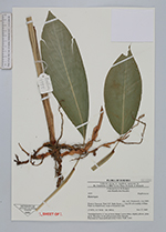
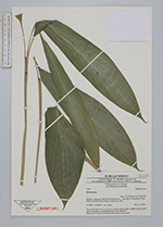
| Collector | Poulsen, A. D. |
| Number | 1955 |
| Collected with | Muhidin bin Masalleh |
| Country | Malaysia |
| Subpart | SARAWAK |
| County | |
| Locality | Niah N.P. Bukit Kasut, c. 1 km SE of township of Batu Niah. Lowland forest, slope of limestone cliff. |
| Coordinates | 3° 49' N 113° 46' E |
| Minimum elevation (m) | 100 |
| Maximum elevation (m) | 100 |
| Start date | 2002/11/27 |
| End date | 2002/11/27 |
| Family | Zingiberaceae |
| Identification | Amomum |
| Determined by | A.D. Poulsen |
| Identification qualifier | |
| Field notes | Terrestrial herb to 0.7 m, in loose clump. Leaves shiny, slightly plicate, plain green. Remains of old inflorescence from rhizome. Deposited at: Sarawak Biodiversity Centre, SAR, AAU. |
| |
| Display all 79 georeferenced records of Amomum Amomum |
| New Search Modify Search |