AAU Herbarium Database |
| New Search Modify Search |
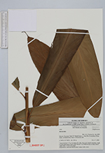
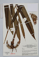
| Collector | Poulsen, A. D. |
| Number | 1954 |
| Collected with | Muhidin bin Masalleh |
| Country | Malaysia |
| Subpart | SARAWAK |
| County | |
| Locality | Niah N.P. Bukit Kasut, c. 1 km SE of township of Batu Niah. Lowland forest, slope of limestone cliff. |
| Coordinates | 3° 49' N 113° 46' E |
| Minimum elevation (m) | 100 |
| Maximum elevation (m) | 100 |
| Start date | 2002/11/27 |
| End date | 2002/11/27 |
| Family | Zingiberaceae |
| Identification | Hornstedtia |
| Determined by | A.D. Poulsen (L), Jan 2003. |
| Identification qualifier | |
| Field notes | Terrestrial herb 1.5 m. In clump. No stilts. Base red, sheath reticulate, rough. Lamina plain green, below pale. Petiole 3 cm. Inflorescence at base, bracts white with c. 5 mm red margin. Deposited at: Sarawak Biodiversity Centre, SAR, AAU. |
| |
 Other records of Hornstedtia Other records of HornstedtiaThe map displays only records from the Aarhus Herbarium Database. The records may not represent the full distribution of Hornstedtia |
| New Search Modify Search |