AAU Herbarium Database |
| New Search Modify Search |
| Collector | Poulsen, A. D. |
| Number | 1903 |
| Collected with | Murang Tadam & Palung Lasung |
| Country | Malaysia |
| Subpart | SARAWAK |
| County | |
| Locality | 7th Div. Between Bakelalan and Gunung Murud. Montane forest. Ridge board walk to Batu Lianit. |
| Coordinates | 3° 56' N 115° 32' E |
| Minimum elevation (m) | 2200 |
| Maximum elevation (m) | 2200 |
| Start date | 2002/11/06 |
| End date | 2002/11/06 |
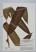
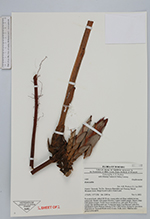
| Family | Zingiberaceae |
| Identification | Hornstedtia |
| Determined by | A.D. Poulsen (L), Jan 2003. |
| Identification qualifier | |
| Field notes | Terrestrial herb, stilted 20-30 cm, young stilts red. Base reddish-brown, pubescent. Sheath with purple blotches. Ligule reddish purple. Bracts white with purple margin. Fertile bracts membranous, pale pink. Petal lobes orange red, labellum dark red. Vernacular name (Lun Bawan): tubu ibot. Informed by Labo Balang Gukang, 8 Nov 2002 before drying the specimen. Deposited at: Sarawak Biodiversity Centre, SAR, AAU. Material also preserved in spirit. |
| |
 Other records of Hornstedtia Other records of HornstedtiaThe map displays only records from the Aarhus Herbarium Database. The records may not represent the full distribution of Hornstedtia |
| New Search Modify Search |