AAU Herbarium Database |
| New Search Modify Search |
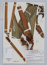
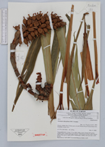
| Collector | Poulsen, A. D. |
| Number | 1811 |
| Collected with | Linus Banggilon, Kho Ju Ming & Henry Baindang |
| Country | Malaysia |
| Subpart | SABAH |
| County | |
| Locality | Km 35 from gate towards Maliau Basin Conservation Area. Roadside in open area. |
| Coordinates | 4° 37' N 116° 56' E |
| Minimum elevation (m) | 440 |
| Maximum elevation (m) | 440 |
| Start date | 2002/03/27 |
| End date | 2002/03/27 |
| Family | Zingiberaceae |
| Identification | Sulettaria A.D. Poulsen & Mathisen |
| Determined by | Axel D. Poulsen |
| Identification qualifier | |
| Field notes | Terrestrial herb in clump, 2-3 m. Stem yellow-green, lamina dark green, midrib yellow, lamina plain green below. Inflorescence at base, erect, flowers white, fruits green to pale yellow (when ripe). Arillus with sour taste, seeds brown. Deposited at: SAN, KEP, Universiti Malaysia Sabah, AAU. |
| |
 Other records of Sulettaria Other records of SulettariaThe map displays only records from the Aarhus Herbarium Database. The records may not represent the full distribution of Sulettaria |
| New Search Modify Search |