AAU Herbarium Database |
| New Search Modify Search |
| Collector | Poulsen, A. D. |
| Number | 1747 |
| Collected with | Januarius Gobilik & Sakai Mulung |
| Country | Malaysia |
| Subpart | SABAH |
| County | |
| Locality | Ulu Padas, NW of Long Pasia village. Grazed forest. |
| Coordinates | 4° 25' N 115° 44' E |
| Minimum elevation (m) | 1025 |
| Maximum elevation (m) | 1025 |
| Start date | 2002/03/15 |
| End date | 2002/03/15 |
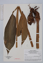
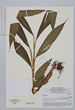
| Family | Zingiberaceae |
| Identification | Hornstedtia |
| Determined by | A.D. Poulsen (AAU), 2002. |
| Identification qualifier | |
| Field notes | Terrestrial herb 1.5 m, in cluster, stilt rooted. Sheath with long hairs. Leaves plicate. Inflorescence sessile at base, bracts red, flowers not seen. Vernacular name in Lundayeh: teladan bacuk (informed later by Pengirang Balapang). cf. affinis Deposited at: SAN, KEP, Universiti Malaysia Sabah, AAU. |
| |
 Other records of Hornstedtia Other records of HornstedtiaThe map displays only records from the Aarhus Herbarium Database. The records may not represent the full distribution of Hornstedtia |
| New Search Modify Search |