AAU Herbarium Database |
| New Search Modify Search |
| Collector | Poulsen, A. D. |
| Number | 1507 |
| Collected with | L. B. Pedersen & Berhaman Ahmad |
| Country | Malaysia |
| Subpart | SABAH |
| County | |
| Locality | Crocker Range. Along road between Kota Kinabalu and Tambunan. Near stream 50 m from road in disturbed forest. Penampang District. |
| Coordinates | 5° 51' N 116° 19' E |
| Minimum elevation (m) | 1350 |
| Maximum elevation (m) | 1350 |
| Start date | 2000/09/19 |
| End date | 2000/09/19 |
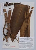
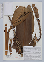
| Family | Zingiberaceae |
| Identification | Sulettaria A.D. Poulsen & Mathisen |
| Determined by | Axel D. Poulsen |
| Identification qualifier | |
| Field notes | Terrestrial herb 4-5 m in dense cluster, slightly stilt-rooted, base of leafy shoot robust, c. 6 cm in diam., c. 12 leaves per shoot, sheaths brown, leaves plain green, pale below, peduncle erect up 0.5 m arising from the rhizome at base of shoot, flower yellow, fruit orange, flowering probably continue for prolonged periods. Material in spirit. Specimen at: SAN, KEP, Universiti Malaysia Sabah, AAU, L, K, E. |
| |
 Other records of Sulettaria Other records of SulettariaThe map displays only records from the Aarhus Herbarium Database. The records may not represent the full distribution of Sulettaria |
| New Search Modify Search |