| Locality | Prefecture Fenoarivo Atsinanana, Sub-prectureVavatenina, Vatovelona forest, ca. 10 km south of the village Manakambahiny 1, Zahmena strict nature reserve (Réserve Naturelle Intégrale), closed forest with undergrowth, gentle slope to flat ground |
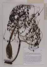
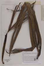
| Field notes | Clustering, slender tree; trunc 7 m high, straight, unarmed, dbh 3 cm; internodes 5 cm; crown with 8 leaves, crownshaft 20 cm long, pale green with brown scales; petiole 5 cm long, adaxial side flat, abaxial side round; rachis 30 cm long, adaxially ridged, abaxially round to flat; leaf shape variable: bifurcate to pinnate, leaflets 40 - 50 cm long, broadly inserted often with "bitten" edges; inflorescence infrafoliar, green, branched to 3rd order, 15 1st order branches, 20 - 30 cm long; peduncle 16 cm long; total inflorescence length 55 cm; fruits green, 1.0 cm long, 0.5 cm wide, the inside is white and ruminate with red patterning; three remaining flower petals, 1 mm; uses: stem used as travers roof beams to attach thatching; local name: Ambosa. |
 Other records of Dypsis