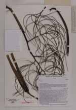
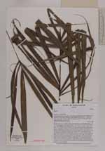
| Locality | Prefecture Fenoarivo Atsinanana, Sub-prectureVavatenina, Ambinany Namantoana forest, ca. 10 km south-southwest of the village Manakambahiny 1, Zahamena strict nature reserve (Réserve Naturelle Intégrale), closed, but rather open forest with undergrowth, medium slope |
| Field notes | Solitary tree; trunc 5 m high, straight, unarmed; dbh 1 cm; internodes green, 1 - 2 cm; crownshaft green with brown scales, 17 cm long, 5 cm wide; petiole 6.5 cm long, green, adaxially flat, abaxially round and covered with scales; rachis 38 cm long , abaxial side flat , green with brown scales, adaxial side ridged, green; leaves pinnate, reduplicate, 12 pinnae on each side of rachis, arranged in groups of 3 - 4 pinnae, distance between groups 40 cm, central pinnae 40 cm long, often with drip tip; inflorescence infrafoliar, branched to 3rd order, 10 1st order branches, total length 50 cm; peduncle 20 cm long, green with brown scales which are irregularly distributed in patches or stripes; prophyl 15 cm long, green with scattered brown scales; flower buds green, threelobed, 1 mm; fruits green, 1.0 cm long, 0.5 cm wide, the inside consists of a ruminate orange layer, 0.2 cm thick and an inner, white core; uses: stem formerly used to make blowdart pipes for hunting purposes; nowadays the stem is used as travers roof beams to attach the thatching and as wall beams; local name: Sinkiara |
 Other records of Dypsis