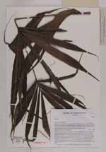
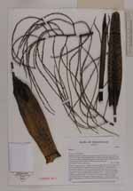
| Locality | Prefecture Fenoarivo Atsinanana, Sub-prectureVavatenina, Vatovelona forest, ca. 10 km south of the village Manakambahiny 1, buffer zone for the Zahamena strict nature reserve (Réserve Naturelle Intégrale), protected area with controlled extraction of forest products, closed forest with undergrowth, gentle slope. |
| Field notes | Slender, solitary tree; trunc straight, unarmed, 6 m high; dbh 2.5 cm; internodes 10 cm; crown with 8 leaves, neatly abscicing; crownshaft 20 cm long, green with reddish scales; petiole 15 cm long, adaxially flat, abaxially round; rachis 40 cm long, round on both sides; leaves pinnate, broadly inserted, arranged in fanshaped groups of 3 - 5 pinnae, distance between groups 20 cm, 3 - 4 groups on each side of rachis, central pinnae 20 - 30 cm long, 5 - 8 cm wide; inflorescence inter- or infrafoliar, branched to 3rd order, 15 1st order branches, 15 - 20 cm long, total length of inflorescence 40 - 50 cm, pendulous; flowerbuds threelobed, green, 1 mm wide |
 Other records of Dypsis