| Locality | Prefecture Fenoarivo Atsinanana, Sub-prectureVavatenina, Vatovelona forest, ca. 10 km south of the village Manakambahiny 1, Buffer zone for the Zahamena strict nature reserve (Réserve Naturelle Intégrale), protected area with controlled extraction of forest products, closed forest with undergrowth, steep slope |
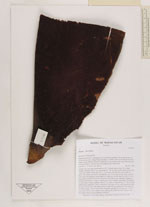
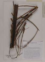
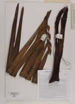
| Field notes | Solitary tree, growing in population of 10 - 20 individuals, trunc 15 m high, straight, unarmed; dbh 21 cm, internodes 10 - 15 cm wide, green with brown scales; leaf scars clearly visible grooves, 2 - 3 cm wide, pale brown; crown with 15 leaves, few marcescent leaves; leaf sheath open, 70 cm long, 40 cm wide, covered with trick red tomentum, inside glabrous bright red; petiole absent; rachis 475 cm long, partly covered with brown tomentum, abaxially round, adaxially channeled near base and with two ridges in distal parts; leaves pinnate, reduplicate, 95 pinnae on each side of rachis, regularly spaced, 7 cm apart, central pinnae 70 - 80 cm long; inflorescence interfoliar, yellow, branched to 3rd order, 15 1st order branches which are up to 50 cm long, total inflorescence length 130 cm; peduncle 60 cm long, 10 cm wide, partly covered with brown tomentum; prophyl 50 cm long, 10 - 15 cm wide; uses: leaves used to thatch roofs, edible grubs collected from rotting wood; local name: Menavozona (meaning "red neck") |
 Other records of Chrysalidocarpus lastellianus