AAU Herbarium Database |
| New Search Modify Search |
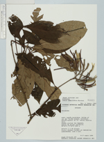
| Collector | Alvarado, A. |
| Number | 165 |
| Collected with | |
| Country | Ecuador |
| Subpart | Napo |
| County | |
| Locality | Canton Archidona. Faldas al sur del Volcan Sumaco. Carretera Hollin-Loreto, km 31. Comuna Challua Yacu. Bosque pluvial Pre Montano. Suelos de origen volcanico |
| Coordinates | 0° 43' S 77° 36' W |
| Minimum elevation (m) | 1200 |
| Maximum elevation (m) | 1200 |
| Start date | 1989/01/08 |
| End date | 1989/01/17 |
| Family | Rubiaceae |
| Identification | Joosia ulei Steyerm. |
| Determined by | C.M.Taylor |
| Identification qualifier | |
| Field notes | Arbusto 3 m de altura. Frutos jovenes verdes, en laminillas redondeadas, olor a aji |
| |
 Other records of Joosia ulei Other records of Joosia uleiThe map displays only records from the Aarhus Herbarium Database. The records may not represent the full distribution of Joosia ulei |
| New Search Modify Search |